|
|
RCFG - 馬祖/南竿 MATSU/NANGAN
|
|
|
|
|
|
1
|
機場之參考點 位置
ARP coordinates and site at AD
|
260935N 1195730E
CENTER POINT of RWY 03/21
|
2
|
與城市之距離方向
Direction and distance from (city)
|
NIL
|
3
|
機場標高/參考溫度
Elevation/Reference temperature
|
232 FT / 31° C
|
4
|
機場標高位置之大地基準面起伏
Geoid undulation at AD ELEV PSN
|
45 FT
|
5
|
磁差/每年改變率
MAG VAR/Annual change
|
5° W ( 2018)/0.08° W
|
6
|
機場管理單位,郵寄地址, 電話號碼,傳真,電傳, 航空固定通信服務地址代字
AD Administration, address, telephone, telefax, telex, AFS
|
馬祖航空站
MATSU AIRPORT OFFICE
連江縣南竿鄉復興村220號
NO.220, FUSING VILLAGE, NANGAN TOWNSHIP, LIENCHIANG COUNTY 209, TAIWAN, R.O.C.
Tel: 886-836-26501
Fax: 886-836-26504
|
7
|
許可飛航類別 (IFR/VFR)
Types of traffic permitted (IFR/VFR)
|
VFR
|
8
|
備註
Remarks
|
Types of traffic permitted: IFR ON CONDITION
|
|
|
|
|
|
1
|
機場管理單位
AD Administration
|
2300-1100 (UTC)
|
2
|
海關及證照查驗
Customs and immigration
|
NIL
|
3
|
衛生及檢疫
Health and sanitation
|
NIL
|
4
|
飛航諮詢
AIS Briefing Office
|
NIL
|
5
|
飛航計畫服務
ATS Reporting Office (ARO)
|
NIL
|
6
|
氣象諮詢
MET Briefing Office
|
From MAR to JUN: 2030-1100 (UTC)
From JUL to FEB: 2100-1100 (UTC)
|
7
|
飛航服務
ATS
|
2230-1030 (UTC)
|
8
|
航空燃油加油服務
Fuelling
|
NIL
|
9
|
機場勤務
Handling
|
2300-0930 (UTC)
|
10
|
安檢單位
Security
|
2300-1000 (UTC)
|
11
|
除冰服務
De-icing
|
NIL
|
12
|
備註
Remarks
|
氣象諮詢與飛航服務將視航情需要,彈性增加服務時間。
MET Briefing Office/ATS operational hours will be lengthened to meet operations.
|
|
|
|
|
|
1
|
貨物裝卸設備
Cargo-handling facilities
|
NIL
|
2
|
燃油/滑油型式
Fuel/oil types
|
NIL
|
3
|
加油設備/能力
Fuelling facilities/capacity
|
NIL
|
4
|
除冰設備
De-icing facilities
|
NIL
|
5
|
來機可用之廠棚
Hangar space for visiting aircraft
|
NIL
|
6
|
來機之修護裝備
Repair facilities for visiting aircraft
|
NIL
|
7
|
備註
Remarks
|
NIL
|
|
|
|
|
|
1
|
住宿設備
Hotels
|
Hotels near the airport.
|
2
|
膳食供應
Restaurants
|
Restaurants near the airport.
|
3
|
聯外交通
Transportation
|
Taxies, Buses
|
4
|
醫療設備
Medical facilities
|
Hospitals in downtown, Military hospital Nr.821
|
5
|
銀行及郵局
Bank and Post Office
|
ATM
|
6
|
旅客服務中心
Tourist Office
|
NIL
|
7
|
備註
Remarks
|
NIL
|
|
|
|
|
|
1
|
機場消防等級
AD category for fire fighting
|
CAT 5
|
2
|
救援裝備
Rescue equipment
|
3000 gallon foam fire engine x 1 and 1500 gallon foam fire engine x 1, equipped in accordance with CAT 5.
|
3
|
故障航空器之移離能量
Capability for removal of disabled aircraft
|
30T Air Bag x 1, flood light rescue equipment x 1, hydraulic rescue equipment set x 1.
|
4
|
備註
Remarks
|
無跑道鋪設泡沫之設施。
No facilities for foaming of runways.
|
|
|
|
|
|
1
|
清除裝備類型
Types of clearing equipment
|
NIL
|
2
|
清除優先順序
Clearance priorities
|
NIL
|
3
|
備註
Remarks
|
NIL
|
|
|
|
RCFG AD 2.8 停機坪,滑行道及核驗點位置
|
|
1
|
停機坪之鋪面與強度
Apron surface and strength
|
APRON
|
CONC
|
PCN 26/R/C/Y/T
|
|
2
|
滑行道之寬度,鋪面類型及強度
Taxiway width, surface and strength
|
A
|
27 M
|
CONC
|
PCN 26/R/C/Y/T
|
B
|
27 M
|
CONC
|
PCN 26/R/C/Y/T
|
|
3
|
高度表校正地點及標高
Altimeter checkpoint location and elevation
|
Location: at Apron
Elevation: 229FT
|
4
|
VOR 校對點
VOR checkpoints
|
|
5
|
INS 校對點
INS checkpoints
|
1
|
260923.88N 1195719.59E
|
NIL
|
2
|
260925.38N 1195720.41E
|
NIL
|
3
|
260926.88N 1195721.23E
|
NIL
|
4
|
260928.38N 1195722.05E
|
NIL
|
5
|
260929.88N 1195722.87E
|
NIL
|
|
6
|
備註
Remarks
|
NIL
|
|
|
|
RCFG AD 2.9 地面活動導引、管制系統及標線
|
|
1
|
停機位編號指示牌,滑行引導線,目視停靠導引系統
Use of aircraft stand ID signs, TWY guide lines and visual docking/parking guidance system of aircraft stands
|
NIL
|
2
|
跑道、滑行道標線及燈光
RWY and TWY markings and LGT
|
RWY markings: RWY designation, THR, TDZ, centre line, edge, end.
RWY LGT: THR, edge, end.
TWY markings: Centre line, edge, RWY-HLDG position.
TWY LGT: Edge.
|
3
|
停止線燈
Stop bars
|
NIL
|
4
|
備註
Remarks
|
NIL
|
|
|
|
|
|
註解:
-
因起飛航道區內無障礙物而無需提供A型機場障礙物圖。
-
B型機場障礙物圖及相關障礙物資訊請洽本局飛航管制組索取。
電話:02-23496118
電子郵件:ais@mail.caa.gov.tw
|
|
|
|
|
1
|
相關氣象單位
Associated MET Office
|
南竿航空氣象臺
Nangan Aeronautical Weather Station
|
2
|
作業時間
作業時間外負責之氣象單位
Hours of service
MET Office outside hours
|
From MAR to JUN: 2030-1100 (UTC)
From JUL to FEB: 2100-1100 (UTC)
南竿航空氣象臺(其他時間視需求提供服務)
Nangan Aeronautical Weather Station (other time on request)
|
3
|
機場氣象預報負責單位
有效時間
Office responsible for TAF preparation
Period of validity
|
臺北航空氣象中心
Taipei Aeronautical Meteorological Center
18HR
|
4
|
趨勢預報
發布間隔
Trend forecast
Interval of issuance
|
TREND
2-hour validity / Hourly
|
5
|
簡報/諮詢方式
Briefing/consultation provided
|
Telephone
|
6
|
飛航文件之資料型態使用語言
Flight documentation
Language(s) used
|
PL, C (Charts, abbreviated plain language text)
Chinese; English
|
7
|
供簡報或諮詢之氣象圖或其他資訊
Charts and other information available for briefing or consultation
|
Surface Wx chart, SIGWX PROG CHART, Upper Level Wx chart
|
8
|
輔助裝備
Supplementary equipment available for providing information
|
AWOS (including Wind measuring
system(2),
system(4),
Visibility(2),
Ceilometer(1),
Ceilometer(2),
Thermograph(1),
Thermograph(2),
Pressure
sensor(1),
sensor(2),
Precipitation
detection(1)),
detection(2)),
and Wind cone(2), JMDS(JAVA-based
Multi-dimensional
Multi dimensional
Display System), Anemometer and Wind vane (1).
|
9
|
收受氣象資料之飛航服務單位
ATS units provided with information
|
南竿機場管制臺, 臺北近場管制塔臺
Nangan TWR, Taipei APP
|
10
|
其他資訊 (服務限制等)
Additional information (limitation of service, etc.)
|
NIL
|
|
|
|
|
|
跑道名稱
Designations RWY
|
真方位
TRUE BRG
|
跑道範圍
Dimension of RWY (M)
|
跑道與緩衝區之強度與鋪面
Strength and surface of RWY and SWY
|
跑道頭經緯度
跑道末端經緯度
大地基準面起伏
THR COORD
RWY end COORD
THR GUND
|
跑道頭標高及精確進場跑道之著陸區最高點標高
THR ELEV and highest ELEV of TDZ of precision APCH RWY
|
1
|
2
|
3
|
4
|
5
|
6
|
03
|
026.29
|
1579 x 30
|
RWY: PCN 26/R/C/Y/T
CONC
Grooved
SWY: NIL
|
260912.20N
1195717.89E
260958.20N
1195743.05E
GUND: 45 FT
|
THR: 221 FT
TDZ: NIL
|
21
|
206.30
|
1579 x 30
|
RWY: PCN 26/R/C/Y/T
CONC
Grooved
SWY: NIL
|
260958.20N
1195743.05E
260912.20N
1195717.89E
GUND: 45 FT
|
THR: 218 FT
TDZ: NIL
|
|
跑道名稱
Designations RWY
|
跑道及緩衝區之坡度
Slope OF RWY and SWY
|
緩衝區範圍
SWY
dimensions (M)
|
清除區範圍
CWY
dimensions (M)
|
跑道地帶範圍
Strip
dimensions (M)
|
跑道端安全區範圍
RESA
dimensions (M)
|
1
|
7
|
8
|
9
|
10
|
11
|
03
|
NIL
|
NIL
|
NIL
|
1700 x 90
|
NIL
|
21
|
NIL
|
NIL
|
NIL
|
1700 x 90
|
NIL
|
|
跑道名稱
Designations RWY
|
攔阻系統位置/說明
Location/ description of arresting system
|
障礙物淨空區
OFZ
|
備註
Remarks
|
1
|
12
|
13
|
14
|
03
|
NIL
|
NIL
|
NIL
|
21
|
NIL
|
NIL
|
NIL
|
|
|
|
|
|
跑道名稱
RWY Designator
|
TORA
(M)
|
TODA
(M)
|
ASDA
(M)
|
LDA
(M)
|
備註
Remarks
|
1
|
2
|
3
|
4
|
5
|
6
|
03
|
1459
|
1639
|
1459
|
1459
|
囿於 RESA 所需土地無法取得,以公布 TORA/ASDA/LDA 距離方式將部分跑道視為跑道末端之 RESA。
In the absence of land, TORA/ASDA/LDA are declared to reclaim a portion of RWY for use as overrun RESA.
|
|
21
|
1459
|
1639
|
1459
|
1459
|
囿於 RESA 所需土地無法取得,以公布 TORA/ASDA/LDA 距離方式將部分跑道視為跑道末端之 RESA。
In the absence of land, TORA/ASDA/LDA are declared to reclaim a portion of RWY for use as overrun RESA.
|
|
|
|
|
|
|
跑道名稱
RWY Designator
|
進場燈型式、長度、強度
APCH LGT type LEN INTST
|
跑道頭燈顏色、有無翼排燈
THR LGT colour WBAR
|
目視進場滑降指示燈 (最低眼高) PAPI
VASIS (MEHT) PAPI
|
著陸區燈長度
TDZ, LGT LEN
|
跑道中心線燈總長度、間距、顏色、強度
RWY Centre Line LGT Length, spacing, colour, INTST
|
跑道邊燈總長度、間距、顏色、強度
RWY edge LGT LEN, spacing colour INTST
|
跑道末端燈顏色、有無翼排燈
RWY End LGT colour WBAR
|
緩衝區燈長度、顏色
SWY LGT LEN (M) colour
|
1
|
2
|
3
|
4
|
5
|
6
|
7
|
8
|
9
|
03
|
RTIL
White
Uni-dir.
Flash FREQ 120/MIN
|
Green
WBAR
|
PAPI
LEFT/3°
(42 FT)
|
Simple TDZ LGT
white,
LIM
Uni-dir.
|
NIL
|
1580M, 60M,
White/Yellow,
LIH
|
Red
No WBAR
|
NIL
|
21
|
RTIL
White
Uni-dir.
Flash FREQ 120/MIN
|
Green
WBAR
|
PAPI
LEFT/3°
(42 FT)
|
Simple TDZ LGT
white,
LIM
Uni-dir.
|
NIL
|
1580M, 60M,
White/Yellow,
LIH
|
Red
No WBAR
|
NIL
|
|
跑道名稱
RWY Designator
|
備註
Remarks
|
1
|
10
|
03
|
-
跑道邊燈:白色,最後560M黃色。
-
簡式著陸區燈設置之目的,係當飛機未於跑道上之某特定點前著陸時,幫助駕駛員於任何能見度條件下掌握場面狀況及決定是否執行重飛(go around)。
-
RWY Edge LGT: White, last 560M yellow.
-
The purpose of simple touchdown zone lights is to provide pilots with enhanced situational awareness in all visibility conditions and to help enable pilots to decide whether to commence a go-around if the aircraft has not landed by a certain point on the runway.
|
21
|
-
跑道邊燈:白色,最後560M黃色。
-
簡式著陸區燈設置之目的,係當飛機未於跑道上之某特定點前著陸時,幫助駕駛員於任何能見度條件下掌握場面狀況及決定是否執行重飛(go around)。
-
RWY Edge LGT: White, last 560M yellow.
-
The purpose of simple touchdown zone lights is to provide pilots with enhanced situational awareness in all visibility conditions and to help enable pilots to decide whether to commence a go-around if the aircraft has not landed by a certain point on the runway.
|
|
|
|
|
|
1
|
機場標燈 /識別標燈之位置,特性及開放時間
ABN/IBN location, characteristics and hours of operation
|
ABN: On top of the tower. White /Green, every 5 sec.
HN or IMC when air traffic control services are provided.
|
|
2
|
降落方向指示器位置及燈光風向風速計位置及燈光
LDI location and LGT Anemometer location and LGT
|
LDI: NIL
Anemometer: NIL
|
3
|
滑行道邊燈與中心線燈
TWY edge and centre line lighting
|
TWY edge light: blue, no center line lighting.
|
4
|
備用電源 /切換時間
Secondary power supply/switch-over time
|
Standby emergency/5-10 sec.
|
5
|
備註
Remarks
|
NIL
|
|
|
|
|
|
1
|
起降區中心或最後進離場區跑道頭之經緯度大地基準面起伏
Coordinates TLOF or THR of FATO
Geoid undulation
|
NIL
|
2
|
起降區及最後進離場區之標高
TLOF and/or FATO elevation M/FT
|
NIL
|
3
|
起降區及最後進離場區之範圍、鋪面、強度、標線
TLOF and FATO area dimensions, surface, strength, marking
|
NIL
|
4
|
進場及起飛區之真方位
True BRG of FATO
|
NIL
|
5
|
公布距離
Declared distance available
|
NIL
|
6
|
進場及最後進離場區之燈光
APP and FATO lighting
|
NIL
|
7
|
備註
Remarks
|
NIL
|
|
|
|
|
|
|
1
|
空域名稱及水平範圍
Designation and lateral limits
|
MATSU/NANGAN AERODROME |
|
2
|
空域上下限
Vertical limits
|
2500FT MSL |
|
3
|
空域類別
Airspace classification
|
Aerodrome traffic pattern. Located in the Matsu Class D Airspace |
|
4
|
航管單位呼號 使用語言
ATS unit call sign
Language(s)
|
NANGAN TOWER
Chinese , English
|
|
5
|
轉換飛行高度
Transition altitude
|
11000FT |
|
6
|
備註
Remarks
|
-
臺北近場管制塔臺負責此空域內所有儀器飛航之管制。
-
於目視天氣情況時,南竿塔臺負責機場航線上航空器活動之管制。
-
南竿機場使用東航線。
-
固定翼航空器不得實施特種目視飛航。
-
ATC service is provided to all IFR aircraft in this area by Taipei Approach.
-
MATSU/Nangan tower provides service to aircraft within the aerodrome traffic pattern under VMC.
-
East traffic pattern is used at MATSU/Nangan AD.
-
Special VFR operation is prohibited for fix-wings aircraft.
|
|
|
|
|
|
任務
Service
designation
|
呼號
Call sign
|
頻率
Frequency
|
作業時間
Hours of operation
|
備註
Remarks
|
1
|
2
|
3
|
4
|
5
|
ATIS
|
NANGAN AIRPORT
|
127.95 MHZ
|
2230-1030 (UTC)
|
NIL
|
TWR
|
NANGAN TOWER
|
118.55 MHZ
|
2230-1030 (UTC)
|
NIL
|
121.50 MHZ
|
NIL
|
236.60 MHZ
|
NIL
|
243.00 MHZ
|
NIL
|
|
|
|
|
|
設施類別、磁差、ILS/MLS類別
(VOR/ILS/MLS 磁偏角)
Type of aid
MAG VAR
CAT of ILS/MLS
(for VOR/ILS/MLS, give declination)
|
識別
ID
|
頻率
Frequency
|
作業時間
Hours of operation
|
電臺發射天線位置
Site of transmitting antenna coordinates
|
DME 天線標高
Elevation of DME transmitting antenna
|
備 註
Remarks
|
1
|
2
|
3
|
4
|
5
|
6
|
7
|
LDA 03
|
INKS
|
110.50 MHZ
|
H24
|
260917.7N
1195717.3E
|
|
前航道區角: 4.2°,
偏架3.29°,
因空域限制,航道中心線左側10°以外以及14NM以外區域, 未經飛測。
Front course sector angle: 4.2˚,
LDA course offset from RWY center line by 3.29˚,
Due to the limitation of airspace, no flight validation performed beyond 10˚ left of the Course Center Line and outside of 14NM.
|
DME 03
|
INKS
|
(CH42X)
|
H24
|
260918.5N
1195717.3E
|
242 FT
|
|
NDB
(04° W)
|
NK
|
315.00 KHZ
|
H24
|
260919.3N
1195718.7E
|
|
|
DME
|
NKN
|
(CH38X)
|
H24
|
260934.3N
1195726.0E
|
375 FT
|
因地形影響,輻向220-020不能使用。
Due to terrain, 220˚-020˚ unusable.
|
|
|
|
|
|
|
|
-
組員應遵守航管指示,航空器不得同時進出相鄰停機位。
-
囿於停機坪土地有限,C130停放於1號停機位時,B 滑行道不可使用。
|
|
|
|
|
|
|
|
|
|
|
2.22.1 傳統到場/進場程序(非RNAV程序)等待點經緯度
|
等待點
Holding Fix
|
經緯度
Coordinates
|
等待點
Holding Fix
|
經緯度
Coordinates
|
|
AICER
|
260850.84N 1200831.02E |
KUMMA |
260338.85N 1200623.75E |
|
RAVIE
|
260521.68N 1200339.28E |
|
|
|
註解: 其他資訊參照ENR 1.5.6及相關航圖。
|
|
|
-
馬祖/南竿機場因地形障礙而為特殊機場。
-
民用航空器所有人/使用人須備妥相關文件向民用航空局申請並經審查授權後,方得使用訂頒之儀器離場程序及儀器進場程序;空中勤務總隊航空器及軍用航空器由權屬機關授權後使用。
-
取得授權之航空器方得於飛航計畫之「飛航規則」欄位寫「I」,否則應依實際飛航規則填寫「Y」、「Z」或「V」。
-
實施授權之儀器進場程序時,不得實施目視進場(Visual Approach)。
|
|
|
本程序僅於馬祖歸航臺(NK NDB)故障,無法全程使用W2或W8航路,且雷達工作正常時適用:
-
由本島機場赴馬祖/南竿機場
航空器通過HIPPO或HAPPY前,如能保持目視,應主動通知航管取消儀器飛航;如無法實施儀器進場或保持目視飛航,則由航管引導返航。
-
由馬祖/南竿機場返臺灣本島機場
航空器於W2或W8航路途中,如遇NK NDB故障,駕駛員得請求航管雷達引導至GENIE(W2航路)或DEFOE(W8航路),恢復正常航行。
-
使用本程序時,不得使用HIPPO及HAPPY等待航線。
|
|
|
航空器於臺北近場管制塔臺管制下,如無法構成無線電連絡達1MIN以上時,航空器應轉換至馬祖/南竿機場管制臺或其他航管單位試通,如仍無法構成連絡,應將電碼置於7600,並保持5000FT定向鞍部多向導航臺/歸航臺(APU/AP),依無線電失效程序實施。
|
|
|
-
牛角嶺(Niujiaoling)英文簡寫為 NJL;於馬祖/南竿機場例行/特別天氣報告(METAR/SPECI)報文附註組欄位(REMARK)附註牛角嶺10 分鐘觀測平均值。
-
當航空器駕駛員於無線電中提出要求再確認風向風速資訊(wind check)時,由南竿機場管制臺管制員一併提供使用跑道及牛角嶺之2分鐘平均風向風速值。
|
|
|
|
|
|
|
|
|
|
|
鳥種
Type of Bird
|
活動季節與時間
Time of Activity
|
活動區域
Area of Activity
|
飛行高度
Flight Height
|
特性
Characteristics
|
白鷺、黃頭鷺
Egret, Cattle egret
|
全年,4月至6月份有較多數量
Whole year, major activities from APR to JUN
|
機場內草坪
Grass area at the airport
|
GND-300FT |
重約370g,中型鳥種
Weighs around 370g, medium-sized species
|
鴿子
Pigeon
|
全年
Whole year
|
03跑道著陸區兩側草坪
Grass area on both sides of RWY 03 touchdown zone
|
GND-100FT |
重約315g,中型鳥種
Weighs around 315g, medium-sized species
|
麻雀
Tree sparrow
|
全年
Whole year
|
03跑道著陸區兩側草坪
Grass area on both sides of RWY 03 touchdown zone
|
GND-100FT |
重約22g,小型鳥種
Weighs around 22g, small-sized species
|
斑鳩
Dove
|
全年
Whole year
|
21跑道著陸區兩側草坪
Grass area on both sides of RWY 21 touchdown zone
|
GND-100FT |
重約155g,中型鳥種
Weighs around 155g, medium-sized species
|
家燕
Swallow
|
3月至7月份
MAR to JUL
|
跑道、滑行道、停機坪
Runway, Taxiways, Apron
|
GND-50FT |
重約15g,小型鳥種
Weighs around 15g, small-sized species
|
紅隼
Common kestrel
|
1月至3月份
JAN to MAR
|
跑道
Runway
|
GND-300FT |
重約198g,中型鳥種
Weighs around 198g, medium-sized species
|
|
註解: 上表所列之時間係本地時間 (UTC+8),另鳥類飛行高度,係觀察鳥類活動所目測之概估值。
|
|
|
|
|
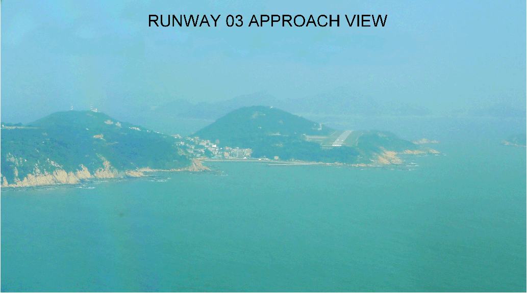
Aerodrome Chart

|
HAPPY 1A(RWY03) DEP, HAPPY 1B(RWY21) DEP (CAA authorization required)
|
HIPPO 1A(RWY03) DEP, HIPPO 1B(RWY21) DEP (CAA authorization required)
|
PETRA ONE ARR (PT1)
|
LDA RWY03 (CAA authorization required)
|
NDB RWY03 (CAA authorization required)
|
RNP RWY03 (CAA authorization required)
|
Aeronautical Data of RNP RWY03
|
RNP RWY21 (CAA authorization required)
|
Aeronautical Data of RNP RWY21
|
RCFG AD 2.25 穿越目視階段保護面之障礙物
|
|
|
|